Egypt is one of the richest countries in terms of mineral wealth; yet, mining contributes only 1% to the Gross Domestic Product (GDP). The reason for that is not the absence of resources, but the lack of information. The country’s last comprehensive national airborne geophysical survey was flown in 1984, leaving commercial explorers reliant on obsolete, low-resolution analogue datasets. That severe data gap has functioned as a $100-billion investment barrier. In May 2026, Egypt moved to close it by contracting Spain’s Xcalibur Smart Mapping to execute a nationwide multi-physics campaign across six survey zones stretching from the Eastern Desert to Sinai. The importance of this survey and the technology behind it lay in replacing forty years of in-complete data with high-resolution digital Earth intelligence. This will directly reduce stage risk, lower entry costs for foreign capital and provide the technical foundation to raise mining’s GDP contribution to 6% by 2030.
What Airborne Geophysics Actually Does
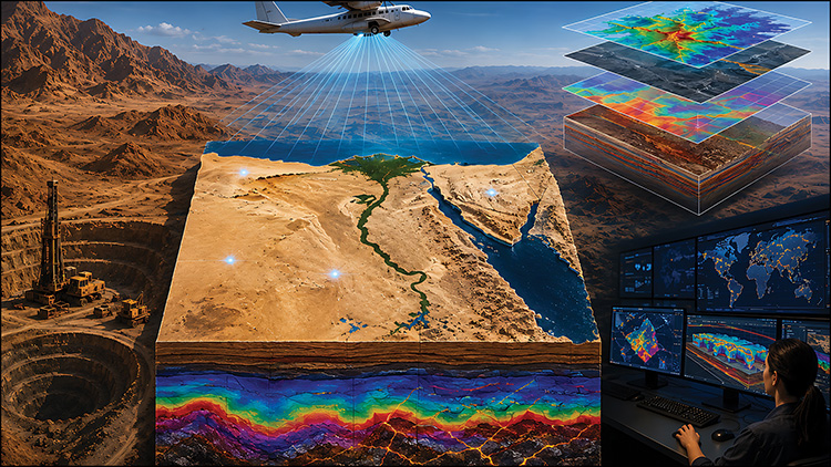
Airborne geophysical surveys deploy sensor-equipped, low-flying aircrafts-typically operating between 10 and 80 meters above the terrain-to measure variations in the Earth’s natural physical fields over vast geographic distances simultaneously. Ground-based field crews require years to map hostile desert terrain; by contrast, a single survey aircraft can acquire between 1,000 and 2,000 line-kilometers of high-density subsurface data every single day.
As detailed in technical survey analysis by Discovery Alert, modern multi-physics platforms simultaneously collect four distinct categories of geophysical data. The first is magnetic surveys, which measure changes in the Earth’s magnetic field caused by iron-rich minerals, helping map underground geological structures and identify potential ore deposits.
The second category is radiometric surveys, which are also known as gamma-ray spectrometry. They detect natural low-level radioactivity emitted by rocks and soils, providing a detailed map of potassium, uranium, and thorium distribution that indicates specific rock types and identifies rare earth elements (REE)-bearing formations. Radiometric surveys can also identify areas of potassium-rich alteration, which is often linked to hydrothermal gold deposits. This makes the technique particularly useful for exploring the Eastern Desert’s mineral-rich areas.
The third type is electromagnetic survey which works differently. They induce electrical currents in the ground and measure the response, identifying conductive bodies associated with base metals including copper, zinc, and nickel. According to GIM International, a specialized Geomatics publication, airborne electromagnetic surveys are among the most effective tools for identifying concealed mineral systems, enabling rapid high-resolution mapping of subsurface electrical conductivity.
The fourth method, gravity surveying, measures small changes in the Earth’s gravitational field caused by differences in the density of underground rocks. This helps identify deep geological structures and deposits of massive sulfide minerals.
As noted in a report by the Mining Weekly publication, combining these multi-sensor streams does not instantly “find” an underground gold mine. Instead, it functions like a medical scan for the Earth’s crust, narrowing the search space from vast desert expanses down to sharp, high-confidence drill targets.
However, the speed advantage over ground surveys is not marginal. A single survey aircraft can cover 1,000 to 2,000 line-kilometres per day. Territory that would take ground-based geological teams years to traverse can be mapped comprehensively in weeks.
Spanish Mapping Technology
To execute a national campaign of this scale, Egypt selected Madrid-headquartered Xcalibur Smart Mapping. The technology brings crucial international precedents to the Egyptian initiative. In Saudi Arabia, the technology was used to complete one of the largest single airborne geophysical surveys ever flown, helping catalyze the Kingdom’s current mineral exploration boom. Similar national mapping projects executed across Nigeria, Botswana, Papua New Guinea, and Vietnam demonstrated that making high-resolution airborne data publicly available leads to an immediate surge in international tenement applications and exploration drilling.
The Egypt Contract: Scope, Structure, and Local Execution
The contract signed at Marsa Alam Airport in May 2026 covers six geographically and geologically distinct survey zones. According to MRMIA, the areas are: the northern and southern Eastern Desert, the northern and southern Western Desert, Sinai, and the Bahariya Oasis and Abu Tartur areas of the New Valley Governorate. Each zone has a different mineral focus: gold, copper, zinc, and REEs in the Eastern Desert; phosphate, iron ore, and uranium in the Western Desert; polymetallic and manganese deposits in Sinai; and iron ore and black sands in the New Valley.
The initiative will provide Egypt with a new generation of high-resolution geological and mineral intelligence designed to support exploration, investment, and long-term resource management. Víctor González, Vice President of Business Development at Xcalibur Smart Mapping, stated that the project “demonstrates how airborne geophysics, AI and Earth Intelligence can help governments build a smarter and more sustainable understanding of their natural resources.”
A key aspect of the contract structure is its deliberate emphasis on indigenization. Xcalibur’s survey aircraft are operating alongside aircraft from Egypt’s Nuclear Materials Authority (NMA), with local drone operator Drone Tech providing operational integration. This partnership ensures that Egyptian geoscientists work directly with advanced processing tools, building domestic capacity to maintain and interpret the national dataset.
What the Data Unlocks: De-Risking Capital for Global Investors
For foreign mining majors and junior exploration funds, high early-stage risk is the primary reason to avoid frontier markets. In the absence of modern geophysics, companies must spend millions of dollars conducting wide-grid manual ground reconnaissance-a slow process with a high risk of failure. Airborne geophysics alters this commercial equation. By providing pre-competitive, standardized digital maps, MRMIA allows incoming exploration firms to evaluate target areas on a computer before committing expensive drill rigs to the field.
Amr Hassan, Agreements and Contracts Expert at MRMIA noted that establishing a standardized, modern national database addresses the critical issue of ‘information asymmetry’ between the government and incoming foreign capital, removing uncertainty that previously hampered contract negotiations: “Investors don’t just ask if a country has mineral potential, they ask whether the data shows where the opportunities lie, how difficult the targets are, and what level of capital makes sense.” He added that if Xcalibur’s survey data is integrated and packaged this way, it could shift from being just another dataset to a core part of Egypt’s investment proposition in future bid rounds. Better geological information can also improve how mining contracts are designed. As Hassan explains, it allows minimum exploration work, spending requirements, and relinquishment terms to be tailored to each area’s geological potential and data quality, rather than using the same terms for every zone. In this sense, the survey is not just a geological tool—it can also help shape better contracts.
What Comes Next: Capturing Value Beyond Data
Data acquisition is not the final step—it is the starting point for sector growth. To capture the full economic value of Xcalibur’s survey, MRMIA must ensure the outputs are published in an accessible digital format that enables fast evaluation and licensing. As per Hassan’s analysis on contract execution, the ultimate goal of the national survey is establishing an efficient cycle of risk allocation: “From an agreements perspective, the real opportunity is not eliminating exploration risk, but making the remaining risk better understood, better priced, and more efficiently allocated between government and investor.”
The global context is highly favourable. Rising demand for critical minerals, energy security, and resilient supply chains is driving mining companies to explore new frontiers. Egypt, with its Arabian-Nubian Shield geology, Mediterranean export corridor, and new nationwide geophysical data, is well placed to benefit. After 42 years, the country is updating its understanding of its mineral wealth. The challenge now is whether its regulatory and institutional framework can turn these targets into producing mines before investors move to the next frontier.